Ironstone Drifts near waterfalls in Carr Wood, Beckhole

Geotag Icon Show on map

The mine entrances are easy to locate adjacent to a waterfall (which is falling over the ironstone deposit)

Waterfalls on West Beck near Ironstone Drift Waterfalls on West Beck near Ironstone Drift
A large area has been carved out in front of the pair of drifts, although it is extremely clogged with water and debris.

Ironstone drift mine entrance near waterfalls Drift mine entrance near waterfalls

Heres the most southerly drift nearest to the waterfall.

Southerly Ironstone drift mine entrance near waterfalls Southerly Ironstone drift mine entrance near waterfalls Southerly Ironstone drift mine entrance near waterfalls

The northerly drift is just as water logged.

Northerly Ironstone drift mine entrance near waterfalls

Drift Entrance in Carr Wood, Beckhole

Geotag Icon Show on map

A number of the mines in this area were buried by a huge landslip in 1864, its is still very apparent today and covers the tramway by the riverside too, I located one drift below a small outcrop, although its difficult to reach.
Drift mine entrance in a cliff Drift mine entrance in a cliff

The drift has wellington height water in the bottom, so on my first visit I was unable to go further than the entrance.
Ironstone drift mine in cliff Ironstone drift mine in cliff Ironstone drift mine in cliff

However on my return visit I was able to explore around the corner, although unfortunately it doesnt continue very far. The tunnel ends with a neatly cut face rather than a collapse suggesting it was some sort of trial rather than a worked area.

End of Ironstone Drift in Carr Wood, Beck Hole Ironstone Drift in Carr Wood, Beck Hole

Beckhole Ironstone Mine

Geotag Icon Show on map

The actual mine was located on the eastern bank of West Beck, but there are more remains on the western bank, the base of a bridge which one carried a tramway still remains. Tramways converged here from mines in Coombs Wood, Hollins Wood and Carr Wood then crossing the river to the calcining field.
Bridge Foundation over West Beck Bridge Foundation over West Beck Bridge Foundation over West Beck

Adjacent to the bridge base is a waterwheel pit clogged with mud and debris, and the remains of a building.
Water Wheel Pit by West Beck Water Wheel Pit by West Beck

Water Wheel Pit by West Beck  Building remains near West Beck

Kilton Castle

Geotag Icon Show on map

This is my first third party contribution courtesy of barender and redpete from redcar.net so many thanks to them for the photos and information. Click on the small thumbnails for bigger photos although not from the usual Flickr.

First things first, this site is on private property belonging to Skelton Estates and they had permission to visit it. If you intend to visit, make sure you get permission too.

The remains visible are of a castle built between 1190 and 1200 by the Kilton family on a long promentary overlooking Kilton Beck. By the mid 1300s it had fallen out of use and was totally abandoned by the 16th century. The area covers approximately 100m x 30m and has been heavily robbed out over the years.
The eastern tower contains a crossbow window, and a huge crack that will eventually lead to its demise.
Kilton 1 Kilton 2

Here are some shots of the same area internally.
Kilton 10Kilton 7

A stretch of the northern wall still remains.

Kilton 3 Kilton 6Kilton 5

Some doorways are still visible in the heavy undergrowth now covering the internally structure, one has been highlighted for us here.

Kilton 9a

Also the remains of a well are visible inside.

Kilton 13

Tees Archaeology has a huge amount of detail on the castle.

Boulby Alum Tunnel

Geotag Icon Show on map

Firstly if you intend to visit this site double check the tide tables before setting off,  to give yourself enough time to get there are back and avoid an air-sea rescue. The cliffs are also very unstable we heard numerous small rock falls and you don’t want to be underneath one.
There are numerous caves and what looks like the remains of a ships boiler on the the way around from Cowbar,
Boiler from a shipwreck ? Boulby Cowbar Cave

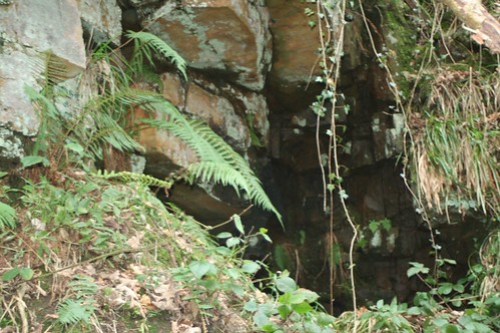
The remains of the 17th Century Alum Tunnel were revealed by coastal erosion in the 1990s. Subsequent landslips and erosion are rapidly removing the tunnel at a rate of several feet per year, and its only a matter of time before a further landslips buries it, or its completely lost to the sea.

Boulby Alum Tunnel Entrance Boulby Alum Tunnel Entrance Boulby Alum Tunnel Entrance

The left-hand tunnel is now eroded nearly all the way back to what looks like a wall, it appear to be built against this wall, rather than actually being a blocked entrance although I cannot be certain if there is another tunnel behind or not. The outside edge of the inner course of bricks has been recently exposed to reveal symbols (perhaps masons marks, or maybe even something to indicate the order of constuction ?) A row of bricks is also visible under the tunnel base.
Boulby Alum Tunnel Marked Bricks  Boulby Alum Tunnel Entrance

The right-hand tunnel is open and contains the remains of sleepers and rails as well as a large pile of washed in stones and debris.
Boulby Alum Tunnel Entrance Boulby Alum Tunnel washed in stones Boulby Alum Tunnel Rails Boulby Alum Tunnel Entrance

Shortly after the pile of debris the tunnel opens into a slightly wider area with a large room off to the right hand side.

Boulby Alum Tunnel Ledge  Boulby Alum Tunnel Side Room

At this point there is a very large roof collapse with a chasm open in the cliff above, knowing the instability of the cliffs I though it wise not to progress any further, despite the tunnel looking in good condition further on.
Tracks can be seen leading off into the distance after the collapse, they would presumably at some point connect with a shaft from the Alum Works at the cliff top.

Boulby Alum Tunnel Collapse Boulby Alum Tunnel

For anyone intending visiting I cannot say enough times, always remember this site is extremely dangerous.

Rosedale East Mines, Low Baring, Old Kilns

Geotag Icon Show on map

The 16 arches of the old kilns are as promentant in the valley as the new kilns also being around 90m long.

There are 4 kilns with 4 arches each, the arches are about 4-5m wide.

Old Kilns Rosedale Ironstone Mines Old Kilns Rosedale Ironstone Mines Old Kilns Rosedale Ironstone MinesOld Kilns Rosedale Ironstone Mines

The upper parts of the kilns have gradually collapsed and are spilling out through the arches.

Old Kilns Rosedale Ironstone Mines Old Kilns Rosedale Ironstone Mines Old Kilns Rosedale Ironstone Mines Old Kilns Rosedale Ironstone Mines  

Above the arches is a ventilation chimney associated with the mine, which stands 7.5m high with a small door at the base allowing a view inside.

Ventilation Chimney Rosedale Ironstone Mine 

Rosedale East Mines, High Baring, New Kilns

Geotag Icon Show on map

The three large bays of the calcinating kilns are about 90m long and can be easily seen from all around the valley.

The iron ore mined here was carbonated which required calcining before smelting.

New Kilns Rosedale Ironstone Mines New Kilns Rosedale Ironstone Mines New Kilns Rosedale Ironstone Mines

New Kilns Rosedale Ironstone Mines New Kilns Rosedale Ironstone Mines

In one of the bays the retaining wall which looks to have been anchored with large wires has collapsed, the faces of wall were once lined with wrought iron which was removed when the mine was abandoned.

New Kilns Rosedale Ironstone Mines  New Kilns Rosedale Ironstone Mines New Kilns Rosedale Ironstone Mines New Kilns Rosedale Ironstone Mines

Ironstone and coal would loaded into the top and calcined ore drawn out from the bottom, it has been estimated that each kiln could produce around 2000 tons of calcined ore a week using about 80 tons of coal.

t has been estimated that each kiln could produce around 2000 tons of calcined ore a week using about 80 tons of coal.In a more complete bay the top courses of fire bricks are balancing precariously on small pins.

New Kilns Rosedale Ironstone Mines New Kilns Rosedale Ironstone Mines

While there are four small tunnels / flues entering the faces of the bay at the base.

New Kilns Rosedale Ironstone Mines New Kilns Rosedale Ironstone Mines