Gazebo in the Garth, Marske

Geotag Icon Show on map

The Gazebo now stands at the side of a residential street, but originally it was part of larger gardens.
Gazebo, The Garth, Marske
Thanks to Neil for the following info :-

The house dates from the late 1700’s and so does the gazebo. Until the early 1960s the house was owned by a doctor who held his surgeries there. The main house was split into two in the mid 1960s and my Aunt and Uncle have lived there since then. The cottage at the end may be older and may have been two residences since it had two staircases one of which has been removed. The gazebo would have provided a view of the sea beyond the garden wall.
Gazebo, The Garth, Marske

John Andrew Malcolmson, North Riding Infirmary

Geotag Icon Show on map

John Andrew Malcolmson was Medical Officer of Health for Middlesbrough until his death aged 46 on 1st March 1898 during a smallpox epidemic (although he died of apoplexy or what we would now call a stroke)
John Andrew Malcolmson Plaque,  North Riding Infirmary
This relief is dated 1899 by Doyle Jones
John Andrew Malcolmson Plaque,  North Riding Infirmary

Again this is now in James Cook Hospital as part of a permanent display.

Sir Bernhard Samuelson Plaque, 1906 North Riding Infirmary.

Geotag Icon Show on map

This plaque once marked the part of the North Riding Infirmary that was erected as a memorial to Sir Bernhard Samuelson by his sons in 1906.

1906 Samuelson Plaque, North Riding Infirmary

The porch in question is the arch that was put around the corner when the hospital was demolished in 2006, as that has a 1906 date stone on it.

Middlesbrough, North Riding Infirmary Arch

The porch and two wings either side are clearly from the later date as they are a different colour to the rest of the 1864 building in this picture.
infirmary
The plaque is currently located in an exhibition at James Cook hospital.

Saltburn Station Subway

Geotag Icon Show on map

The railway lines at Saltburn originally extended directly into the back of the Zetland Hotel as can be seen in this 1950s photo from the East Cleveland Image Archive.

There used to be a pedestrian subway to get under the lines at the rear of the main station.
Saltburn Station Subway
I recall this as a child (early 80s) but cannot remember exactly when it was filled in although this sign on the wall to “Please Be Tidy” is still visible
Saltburn Station Subway
There is a beam stamped with the date 1865, but it cannot now be seen as the area is within someones private garden.

yogi59 has kindly allowed me to use the following photo which shows the subway being filled and the date stamped beam.

Saltburn Subway being filled in

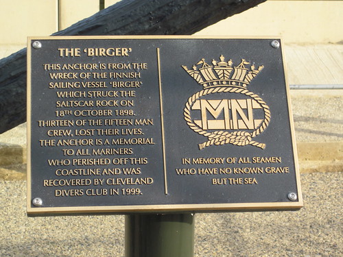
Return of the Birger Anchor

Geotag Icon Show on map

As the redevelopment or Redcar seafront nears completion a lot of the items removed are now coming back.
Birger |Anchor, New Location, Redcar.
The anchor has had a coat of paint and got a new plaque.
Birger |Anchor, New Location, Redcar.
My previous post may not be correct as further research suggests the Birger broke up on the rocks first and parts of it collided with Victoria Pier later, as such this photograph I used last time of a complete ship beached doesnt seem to fit anymore, although the pier does look freshly broken with pieces hanging down.birger.jpg