de Brus Wall, Hart

This fragment of wall near St Mary Magdalene’s Church, Hart is the only above-ground remains of a medieval great house owned from the 12th to the 16th centuries by the de Brus and Clifford Lords.

de Brus Wall Hart

The history is well described in the Scheduled Ancient Monument listing :-

The manor of Hart and Harterness was granted by the king to Robert de Brus
after the Norman Conquest. Documents indicate that the extent of this manor
was larger in pre-Conquest times. Throughout its history, the right of
disposal of the manor was a source of dispute between the Crown and the Bishop
of Durham. The manor subsequently descended through the Brus family most
notably to Robert de Brus VII; after the latter’s assumption to the Scottish
throne in 1306, Edward I granted the manor to Robert de Clifford in whose
family it remained until 1580, with only brief interruption by claims from a
number of bishops. In 1580 the manor was sold to Robert Petrie and John Morley
and then to the Lumley family who, with the exception of a brief period of
administration by Parliament from 1644-1660, retained it until 1770. In 1770
the estate was sold to the Milbank family.

St Mary Magdalene Church, Hart

St Mary Magdalene Church, Hart was founded in 675 AD

St Mary Magdalene Church, Hart

The current tower dates to the 13th century and the nave the 12th century. A carving on the wall is generally said to depict St. George and the Dragon.

St Mary Magdalene Church, Hart

However it could relate to the Clifford Family who owned the Manor House estate. Rather than a dragon it may show a wyvern which features on the Clifford family crest.

Clifford Wyverns at Skipton Castle

Friarage Manor House, Hartlepool

Geotag Icon Show on map

A Franciscan Friary was founded on this site around 1239 by the De Brus family.

Friarage Manor House, Hartlepool

Destroyed during the Dissolution of the Monasteries, a mansion was built in the early 17th century.

Sketch showing the site in ruins in 1780
Friarage Manor House, Hartlepool

In the early 1800s it became the town workhouse, followed by the building being converted into a hospital in the 1860’s.

St Hilda’s Hospital developed on the site and this last original piece was left when the rest was demolished in 1987

Friarage Manor House, Hartlepool

Bombardment of the Hartlepools

Geotag Icon Show on map

On my previous visit to the site in mid-2014 this monument did not exist, it appeared a few months later.

Bombardment of the Hartlepools

It commemorates the death of 114 civilians, 9 soldiers and 7 sailors killed in the Bombardment of the Hartlepools on 16th December 1914.

Bombardment of the Hartlepools

It was erected to mark the 100th Anniversary and unveiled on 16th December 2014 by the Lord-Lieutenant of County Durham Sue Snowdon.

Bombardment of the Hartlepools
Engraving on rear of monument

The engraving is tricky to photograph, but it a reproduction of the painting The Bombardment of the Hartlepools by James Clark, painted in 1915.

The Bombardment of the Hartlepools by James Clark, painted in 1915

A huge amount of information about the events of that day is on display in the nearby Heugh Battery.

Bombardment of the Hartlepools Fragment
Shrapnel from December 16th 1914

Brougham Terrace Stench Pipe, Hartlepool

Geotag Icon Show on map

It’s a long time since i’ve visited Hartlepool now that I no longer work near there.
Hartlepool Stench Pipe
It was nice to come back for a Stench Pipe though !
Hartlepool Stench Pipe
I suspect there are a lot more out there in Hartlepool of a similar age.

100th Anniversary of Bombardment of Hartlepool

100 years ago today 1500 shells were fired at Hartlepool during the bombardment by the German Cruisers Seydlitz, Moltke and Blucher. Leading to the death of the first soldier killed on British soil during the First World War.
First Soldier Killed on British Soil in World War 1, Hartlepool
A series of events took place today to mark the occasion

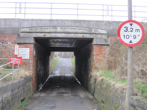
T. Richardson, Hartlepool Iron Works 1851, Moorhouse Estate

Geotag Icon Show on map

Thomas Richardson had acquired the Hartlepool Iron Works in 1847 and this bridge lintel is dated 1851. Although it doesnt appear to be structural as the surround bridge is much newer.
T. Richardson, Hartlepool Iron Works 1851, Moorhouse Estate.
A friend at Network Rail informs me there is a 1940 steel deck built from old rails that carries no tracks.
T. Richardson, Hartlepool Iron Works 1851, Moorhouse Estate.
The live line are carried by a modern steel slab deck installed in 1989.

Hart Windmill

Geotag Icon Show on map

Hart Windmill was built in the 19th Century and was operational until 1915, although a mill is thought to have stood on the hill since 1314
Hart Windmill
It was restored in 1991 as previous to that it had no wooden cap, although it still lacks any sails.

Pillbox, Worset Lane, High Throston

Geotag Icon Show on map

This pillbox is stranded in a gated housing development at the southern corner of the golf course.
Hartlepool Pillbox, Worset Lane
It looks like all the opening have been blocked, but it cannot be approached for a closer look.
Hartlepool Pillbox, Worset Lane

Pillbox behind Nuthatch Close, High Throston

Geotag Icon Show on map

The area to the North-West of Hartlepool seems to have been a heavily defended during World War 2.
Hartlepool Pillbox, Nuthatch Close
Here is another example of a pillbox in that area, although sadly this one is sealed up and covered in grafiti.
Hartlepool Pillbox, Nuthatch Close