Eston Ironstone Obelisks

Geotag Icon Show on map

Following on from my previous obelisk post I went out to photograph the two ironstone obelisks on the site of the old Eston miners hospital.

Eston Ironstone Obelisk Eston Ironstone Obelisk

Eston Ironstone Obelisk  

They were removed when the hospital was demolished in 1980 and returned in 2004. They are identical to the two outside the town hall, so i’m unsure where these two went or if there were four at the town hall ?


Boiling Well or Abba (Abbey) Well, Whitby

Geotag Icon Show on map

Boiling Well, Whitby Boiling Well, Whitby

Boiling Well, Whitby

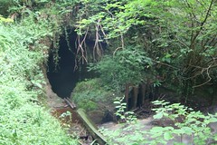
Currently the plaque says :-

“In the early nineteenth century Mr Joseph Brown piped water from this spring to a reservoir in the grounds of Whitby Abbey, to provide a clean and reliable water supply to the east side of Whitby”

Apparently a few years ago there was a different plaque. which read.

T’awd Abba Well
Also known as the old Boiling Well

Lang centuries aback
This wor’t awd Abba Well
Saint Hilda veiled i’ black
Lang centuries aback
Supped frey it an no lack
All t sisterhood as well
Lang centuries aback
This wor’t awd Abba Well

Not the best photos in the world, as I only had a mobile phone with me.

Update January 2009

Sheila Welch has kindly provided some slides of the well taken in the 1970s by her father George Towndrow, these show the original plaque still in place.

Abba Well, Whitby 70s

Abba Well, Whitby 70s

Redcar Penguins

Geotag Icon Show on map

Redcars much loved penguin colony created by “The Great British Bollard Company” moved from their old location with the building of the new bandstand

Redcar Penguins Redcar Penguins

There were temporarily removed to a ‘secret’ location in 2006 for the filming of Atonement, as apparently no concrete penguins were present during the Dunkirk evacuation.

UPDATE : As of August 2012 the penguins are gone again. I don’t know whether they will return to the sea-front when the redevelopment is completed.
UPDATE : The penguins are back in a new location in 2013

South Skelton Ironstone Mine

Geotag Icon Show on map

The most prominant building on site is the square compressor & haulage engine house.

 South Skelton Ironstone Mine South Skelton Ironstone Mine

The attached upcast winding house is situated adjacent to the capped shaft (216 feet deep – capped c.1985), a guide roller can still be seen in the slot through which the cables travelled. 

South Skelton Ironstone Mine South Skelton Ironstone Mine

South Skelton Ironstone Mine South Skelton Ironstone Mine

The wooden stable blocks and unique for the area, and its pretty amazing they havn’t been demolished or burnt down when you see the general state of the site and people who hang around there.

South Skelton Ironstone Mine South Skelton Ironstone Mine

South Skelton Ironstone Mine South Skelton Ironstone Mine

South Skelton Ironstone Mine South Skelton Ironstone Mine

Numerous other buildings can be seen around the site, which is remarkably complete.

South Skelton Ironstone Mine South Skelton Ironstone Mine

South Skelton Ironstone Mine South Skelton Ironstone Mine

(note the weather wasn’t wildly changable that day, the photos are taken about sixth months apart)

Grinkle Ironstone Mine, Culvert

The culvert runs underneath the site of the Grinkle Ironstone mine.
Internally the culvert is on the verge of total collapse, so I really wouldn’t recommend emulating my visit, a previous collapse in 1927 flooded the mine and trapped miners underground.
Grinkle Culvert Culvert

At the southern entrance of the culvert a large pool of water has backed up due to a collapse, here the tunnel seems to be cut into solid rock.
Culvert Culvert  

Lady Chapel, Mount Grace, Osmotherley

Geotag Icon Show on map

The Lady Chapel was originally in the 15th century near a holy spring above the Carthusian priory of Mount Grace and continued to be a place of pilgrimage for centuries, it was a ruin until the late 1950s after which it was rebuilt.

Lady Chapel, Mount Grace, Osmotherley Lady Chapel, Mount Grace, Osmotherley Lady Chapel, Mount Grace, Osmotherley

Castleton Silica Quarry Tramways

Geotag Icon Show on map

Taken as the sun cast a shadow over them last autumn.

Castleton Inclines Castleton Inclines

The left-hand incline leads to an 1895 western silica quarries, the more prominent right-hand incline leads to the 1919 main and eastern silica quarries.The remains of a quarry can clearly be seen in the hillside center-right.
The silica works was at the bottom of the right-hand incline where the road to Castleton passed under the Esk Valley Railway.

Upleatham Ironstone Mine, East Winning Hauling Engine

Geotag Icon Show on map

This second set of brickwork hauling engine bases mark the location of the East Winning drift, which was an open drift mouth until the early 1970s, nothing remains now other than a large depression in the hillside.

Upleatham Ironstone Mine East Winning Haulage Engine Upleatham Ironstone Mine East Winning Haulage Engine Upleatham Ironstone Mine East Winning Haulage Engine

Just to the east of this area, Quarry Lane is reached. Some remains of a bridge underneath the road are visible

In the woodland to the east of the lane there are many traces of ironstone quarrying and some concrete bases, possibly for an aerial ropeway that carried ironstone from Hob Hill mine to the east to be loaded into wagons at Upleatham.

Upleatham Ironstone Mine, Main Winning Hauling Engine

Geotag Icon Show on map

Situated at the top of Pontac Road, these brickwork Hauling Engine bases in the undergrowth are part of the scant remains of the second highest output mine in the area. The Drift itself was just a short distance to the south although no trace remains other than a depression in the ground.

 Upleatham Ironstone Mine Main Winning Haulage Engine Upleatham Ironstone Mine Main Winning Haulage Engine Upleatham Ironstone Mine Main Winning Haulage Engine

 A new gate has been erected in late 2008 which give some clue to the ironstone mining past.

Upleatham Ironstone Mine Commemorative Gate 

Â