Sheriffs Pit, Rosedale

Geotag Icon Show on map

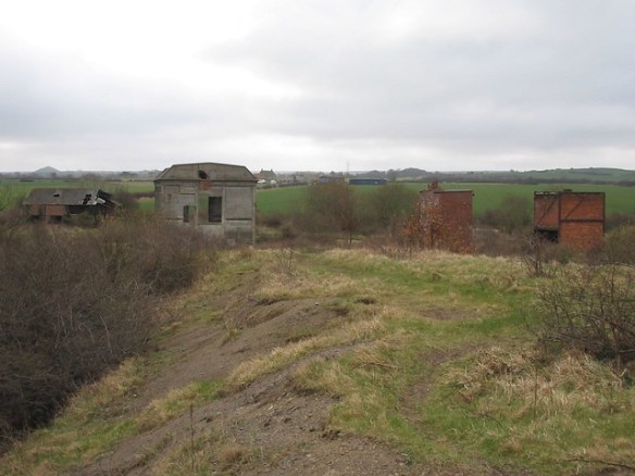
Its difficult to imagine such a picturesque place once being an area of heavy industry. The pit closed in 1911 but the shaft is open and only surrounded by a fence, a constant rush of water being heard from inside.
Rosedale, Sheriffs Pit 1
The corner of the mine managers house remains standing (although I don’t know for how much longer)
Rosedale, Sheriffs Pit 2
Rosedale, Sheriffs Pit 4

St Thomas a Beckets Church, Grindon

Geotag Icon Show on map

Originally built in the 12th century, in use until 1848 when it was abandoned due to the opening of a new church in Thorpe Thewles (which was itself replaced in 1885 with the current church)
Grindon Church 1
Grindon Church 2
Grindon Church 6
Grindon Church 7

Guisborough Milestone

Geotag Icon Show on map

Situated on cemetery corner at the junction with the Redcar road. Currently I have no idea of its age or origins, although the fact it points to Kirkleatham rather than Redcar is perhaps a clue.
Milepost Guisborough

Site of the bombed Zetland Club, Redcar

Geotag Icon Show on map

The Zetland Club was hit by a bomb on 21st October 1941. Amongst the 15 killed were the mayor, councillors and a doctor. Zetland Club Redcar Plaque
Alderman Charles Harris J.P.
Frank Bainbridge. (Builder)
John C.D. Barnett. (School Master)
William Crozier. (Bank Manager)
Mabel Fletcher. (Club Stewardess)
Charles H. Goodwin. (Optician)
Arthur Pickering J.P. (Chairman of the local magistrates)
Matthew Ranson (Retired School Master)
Doris R. Rigby. (Club Maid)
Dr. Alfred S. Robinson.
Joseph Roebuck. (Councillor)
William J. Smallwood. (Company Commercial Manger)
Doris Walton.
Harold Watson.
Marion Watson.
Zetland Club Redcar Plaque
The garden of rememberance also has plaques for those lost at sea and Dunkirk.
Zetland Club Redcar

Redcar Rocks

Geotag Icon Show on map

I’ve had this scrap of paper that I bought from the lifeboat shop for at least 20 years, I’ve rewritten the legend but the rest is straight from the original.

Shipwreck on Bran Sands, South Gare, Redcar

Geotag Icon Show on map

I’ve not yet found any record of the ships name, or date it was wrecked.
Bran Sands Shipwreck 2
Bran Sands Shipwreck 1
The remains of the ship can be seen depending on the tides and sand levels.
Bran Sands Shipwreck 3
Bran Sands Shipwreck 4

Redcar Sound Mirror

Geotag Icon Show on map

Built around 1916 to detect approaching Zeppelins, now sits surrounded by houses but safe due to being a scheduled ancient monument.
Redcar Sound Mirror 1
The base of the column where the listening trumpet was mounted is a few feet in front of the mirror.
Redcar Sound Mirror 2
Information on other Sound Mirrors in the UK can be found here

Kilton Ironstone Mine

Geotag Icon Show on map

The shale heap is visible from miles around and a number of building survive on the ground.

Kilton Ironstone Mine 1
Kilton Ironstone Mine 4
Kilton Ironstone Mine 9
Kilton Ironstone Mine 8
Kilton Ironstone Mine 5
Although one building, possible a workshop is in danger of complete collapse.
Kilton Ironstone Mine 3
The winder house is much more sturdy as its built from reinforced concrete, although in recent years the steps pictured have collapsed

Note: This substantial structure was subsequently demolished and is sadly no longer on the site
Kilton Ironstone Mine 2
The capped 694ft shaft is also visible
Kilton Ironstone Mine Shaft
In the side of a small shale heap is a small tunnel, perhaps some kind of shelter or storage area as this isn’t a drift mine.
Kilton Ironstone Mine 6
Kilton Ironstone Mine 7
Away in the woods to the east is a small building, I initially though it may be a powder magazine but its not very sturdy and a 1950s map shows a meter house for the Cleveland Water Company in this area.
Kilton Ironstone Mine Water Meter House 2
Kilton Ironstone Mine Water Meter House 1