This pillbox now stands alone in the middle of a field between Kirbymoorside and Keldholme.


 The countryside location may seem unusual now, but wartime air base RAF Wombleton is nearby.
Kirkbymoorside Pillbox
1
 Show on map Show on map
 This pillbox now stands alone in the middle of a field between Kirbymoorside and Keldholme.
The countryside location may seem unusual now, but wartime air base RAF Wombleton is nearby.
Show on map Victoria Cross overlooks the village of Lastingham

The base carries an inscription “Victoria R.I 1897” which relates to the Diamond Jubilee of Queen Victoria for which it was erected.
R.I. stands for Regina et Imperatrix (Queen and Empress) 
The other side carries the inscription “V.R. 1837” marking the start of her reign.

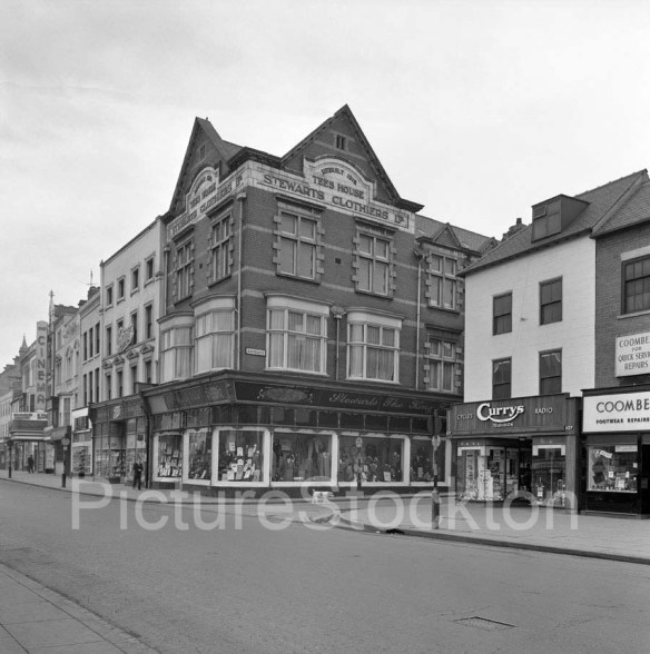
Show on map Stewarts Clothiers occupied this site from 1896 and 1963

The existing building is inscribed as having been rebuilt in 1912.
This photo from Picture Stockton show it shortly before closure in 1962.
During WW2, the couple that then lived in our home had a custom built shelter dug! She wanted her own shelter, especially after 6 houses were brought down in an air raid! He, was a retired civil engineer, and hence a pretty nifty piece of work!Scroll on to 2014, by which time the roof had long been removed, a concrete slab, and the hole filled in and a garden created to our having to dig up said garden to find source of damp problem – blocked air bricks which had been covered over with concrete when garden recreated! We found the top step which, had a pivot hole at one end and decided to dig down! The rest you can see, nobody in the street remembers it but one gentleman, now in his late 80’s, does remember the shelter being there.


Show on map This new gondola was installed in early 2015 as part of £2.6m renovations

Still not as nice as the original mind you.

Show on map The outer wall of the waterwheel in Liverton has the remains of a painted sign for an old licensee.

Francis Pybus of the Downe Arms, his family are listed on the 1891 census as follows.
Downe Arms
Francis Pybus / head / M / 57 / Liverton, Yks
Jane Pybus / wife / 48 / Lofthouse, Yks
Francis Pybus / son / S / 24 / Liveton, Yks
Sarah Pybus / daug / S / 20 / Liverton, Yks
Thomas Pybus / son / S / 19 / Liverton, Yks
John Pybus / son / S / 17 / Liverton, Yks
Annie Pybus / daug / S / 14 / Liverton, Yks
Joseph H Forster / son in law / M / 27 / Lealholm, Yks
Mary Forster / daug / M / 22 / Liverton, Yks
Show on map Roseberry Square library has a new plaque that marks the location of the First World War, Royal Naval Air Station.

Erected by the Friends of Redcar Cemetery, the plaque was unveiled by John H Watson, Author of ‘Aces High at Redcar’ on 4th July 2015
Show on map The sign outside MPI (which used to be Tata Steel R&D) is built from the tuyeres of the Bessemer converters from the Cleveland Steelworks

I visited this larger section back in 2009.

Show on map Back in 2012 when I took this photo, the building looked rather sorry for itself.
 Its amazing what a coat of paint can do to improve things.
Show on map Ripon Camp was a vast First World War camp, it could accommodate 30,000 troops and an estimated 350,000 men passed through during the course of the war.

A huge military hospital with 670 beds stood opposite the turning to Studley Roger, this was demolished after the war and is where the memorial now stands, of the site of the chapel and canteen.

A collection of photos can be found courtesy of the Kings Own Royal Regiment.