Hinderwell ROC Post – Back to where it all began.

Geotag Icon Show on map

In May 2002 I was fortunate enough to visit this post when it was dry and completely intact, there were maps on the walls, magazines in the drawers and even a message left by the last watch. Before I could return and take photographs the entrance was filled with soil and access was lost. Luckily Nick Catford managed to get photos around that time.
I always regretted the missed opportunity and not having recorded it when I had the chance, so those events were in my mind when I came to start up this website.
However after a lost decade the site is once again open.
Hinderwell ROC Bunker
Sadly due to the lid being thrown down the hole, water is getting in its in poor condition.
Hinderwell ROC Bunker
This metal plate was where the ‘Bomb Power Indicator’ was mounted.
Hinderwell ROC Bunker
The air vent has taken a lot of abuse, being nearly smashed to pieces.
Hinderwell ROC Bunker
Inside the entrance is now half-filled with soil
Hinderwell ROC Bunker
The contents of the post is generally trashed and all the papers and maps gone.
Hinderwell ROC Bunker
A couple of nice features still remain, such as a hand-written note about sounding the siren, protected from damp by glass.
Hinderwell ROC Bunker
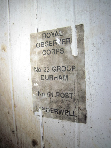
The back of the door also has a notice of the post name and number still attached.

Anti-tank Defences – Millclose Howle, Redcar

Geotag Icon Show on map

Coastal erosion has recently revealed what I believe are the foundations of WW2 anti-tank cubes at Millclose Howle, they were not visible on the current Google Earth images.
WW2 Anti-Tank Remains, Millclose Howle, Redcar
The cubes would have blocked access at this point by invading tanks.
WW2 Anti-Tank Remains, Millclose Howle, Redcar
The cubes themselves were probably destroyed soon after the war, but these stubs remain.
WW2 Anti-Tank Remains, Millclose Howle, Redcar
A block of three is fully revealed, but there are more still hidden under the soil that appear more intact.
WW2 Anti-Tank Remains, Millclose Howle, Redcar

Job Cross

Geotag Icon Show on map

Job Cross now stands isolated, a distance from the current footpaths and roads.
Job Cross
It originally marked where the Castleton to Moorsholm road crossed the Old West Road.
Job Cross
It is relatively modern (c1800) compared to some moorland crosses and features herringbone patterns on the sides.

Lowna Quaker Burial Ground

Geotag Icon Show on map

114 local quakers were buried here between 1675 and 1837.
Quaker Burial Ground, Lowna
(or 1854 depending on which plaque you believe)
Quaker Burial Ground, Lowna
The site is still maintained by Quakers from Kirkbymoorside, although no gravestones or monuments remain inside the enclosure.
Quaker Burial Ground, Lowna

Duffin Stone, Farndale

Geotag Icon Show on map

Duffin Stone is a natural rock feature that stands right on the edge of the road in Farndale.
Duffin Stone, Farndale
Despite it’s location it’s never been removed and is now deeply scored and marked with paint from passing traffic.
Duffin Stone, Farndale

Sun Inn, Spout House, Bilsdale

Geotag Icon Show on map

Spout House is a 16th century cruck framed farmhouse, named after a nearby spring.
Sun Inn, Spout House, Bilsdale
It became an ale house known as the Sun Inn in 1714
Sun Inn, Spout House, Bilsdale
The new pub opposite the house was built in 1914 and the original Sun Inn closed.Sun Inn, Spout House, Bilsdale
Remarkably the old house was then left undisturbed with its original furniture until 1979 when it was taken over and re-opened by the National Park Authority.
Sun Inn, Spout House, Bilsdale
An upper bedroom gives a view of the A-shaped cruck frame.
Sun Inn, Spout House, Bilsdale
Illustrations from ‘Englands Oldest Hunt’ published in 1907.
sh2
sh

Mary Magdalene Well, Lastingham

Geotag Icon Show on map

The hardest to find of Lastinghams four holy wells, despite being only a few meters from the roadside, it took me several attempts due to vaguery in the OS map.
Mary Magdalene Well, Lastingham
The well was re-dug in 1964 by a Mr H. Frank.
Mary Magdalene Well, Lastingham

High Cross, Appleton-le-Moors

Geotag Icon Show on map

A short distance up the road to Lastingham from yesterdays Low Cross, is High Cross
High Cross, Appleton-le-Moors
This is another medieval wayside cross which has become broken at some point in the past.
High Cross, Appleton-le-Moors
Also a Grade II Listed Building, it stands at the junction of Kirkgate Lane and Wensdale Lane.

Low Cross, Appleton-le-Moors

Geotag Icon Show on map

This medieval cross could be easily missed despite being a Grade II listed building. It may actually be an earlier prehistoric standing stone.
Low Cross, Appleton-le-Moors
It looks like a sign or plaque was attached at some point in the past.

Cropton Water Hydrant

Geotag Icon Show on map

This cast iron water hydrant dates from 1899.
Cropton Water Hydrant
The broken top allows the mechanism to be seen.
Cropton Water Hydrant
The makers plate read “J Blakeborough & Sons Manufacturers Brighouse England”
Cropton Water Hydrant
These were installed when the village water supply was introduced by Firth of Scarborough.