Sir Bernhard Samuelson Plaque, 1906 North Riding Infirmary.

Geotag Icon Show on map

This plaque once marked the part of the North Riding Infirmary that was erected as a memorial to Sir Bernhard Samuelson by his sons in 1906.

1906 Samuelson Plaque, North Riding Infirmary

The porch in question is the arch that was put around the corner when the hospital was demolished in 2006, as that has a 1906 date stone on it.

Middlesbrough, North Riding Infirmary Arch

The porch and two wings either side are clearly from the later date as they are a different colour to the rest of the 1864 building in this picture.
infirmary
The plaque is currently located in an exhibition at James Cook hospital.

Saltburn Station Subway

Geotag Icon Show on map

The railway lines at Saltburn originally extended directly into the back of the Zetland Hotel as can be seen in this 1950s photo from the East Cleveland Image Archive.

There used to be a pedestrian subway to get under the lines at the rear of the main station.
Saltburn Station Subway
I recall this as a child (early 80s) but cannot remember exactly when it was filled in although this sign on the wall to “Please Be Tidy” is still visible
Saltburn Station Subway
There is a beam stamped with the date 1865, but it cannot now be seen as the area is within someones private garden.

yogi59 has kindly allowed me to use the following photo which shows the subway being filled and the date stamped beam.

Saltburn Subway being filled in

Yarm 1881 Flood Marker

Geotag Icon Show on map

Yarms position in the bend of the River Tees made it vulnerable to flooding, this marker on the Town Hall shows the height of the March 10th 1881 flood waters.
Yarm Flood 1881#
There is a second higher marker for September 17th 1771, although this is currently hidden by a wooden panel in the doorway.

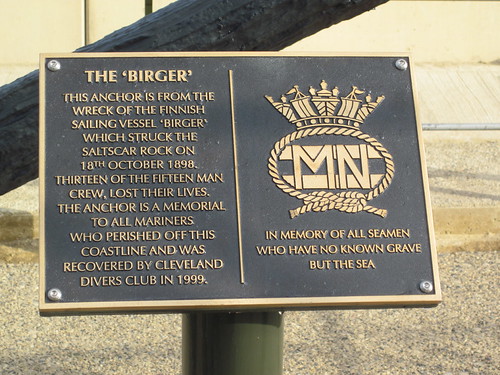
Return of the Birger Anchor

Geotag Icon Show on map

As the redevelopment or Redcar seafront nears completion a lot of the items removed are now coming back.
Birger |Anchor, New Location, Redcar.
The anchor has had a coat of paint and got a new plaque.
Birger |Anchor, New Location, Redcar.
My previous post may not be correct as further research suggests the Birger broke up on the rocks first and parts of it collided with Victoria Pier later, as such this photograph I used last time of a complete ship beached doesnt seem to fit anymore, although the pier does look freshly broken with pieces hanging down.birger.jpg

Ketton Ox, Cockpits, Yarm

Geotag Icon Show on map

The core of this inn dates from the late 17th century, although it has been heavily modified over the years.
Ketton Ox, Yarm
The filled oval windows were once over cock-pits, an area used for cock fighting,
Ketton Ox, Cockpits, Yarm
This common ‘entertainment’ was banned in England in 1835.
Ketton Ox, Yarm

Tom Browns House, Yarm

Geotag Icon Show on map

After covering his birth and death. Heres a final post on his house in Yarm.

Tom Browns House, Yarm

Although the current frontage is more modern, underneath is said to be a 15th Century timber structure from the Inn

Tom Browns House, Yarm

Much more detail, including a photograph of the Inn sign can be found on Bob’s Home For Writing.

Bortner Jeweller Ghostsign – Redcar

Geotag Icon Show on map

This old ghostsign had stood high and dry for decades on Dundas Street.
Bortner old painted sign, Redcar
Sadly in the last few days its been painted over rather than the owner of the building thinking to preserve it, personally I think it would have been a nice talking point to repaint it.

Tom Browns Grave, Yarm

Geotag Icon Show on map

I have previously covered Tom Browns Tree which marks his 1705 birthplace, so today his grave which is a replica of a Commonwealth War Graves Commission headstone that was presented by the Queen’s Own Hussars in 1968.
Tom Browns Grave, Yarm
As previously mentioned he is known for his role in the Battle of Dettingen which took place on 27th June 1743 in Bavaria during the War of the Austrian Succession.
His regiments standard was captured and while recovering it he received terrible injuries to his face including his nose being cut off. He is said to have been given a silver nose by King George II.
tombrown
He retired to Yarm with a pension of 30 shillings from the King, as two shots from the battle could not be safely removed from his back, he died there in 1746.

Dominican Friary Wall, Yarm

Geotag Icon Show on map

A Dominican Friary (“Black Friars”) existed in Yarm from some time before 1266 until the Dissolution of the monasteries by Henry VIII in 1539 Friary Wall, Yarm
This boundary wall remains.
Friary Wall, Yarm

Hope House, Yarm

Geotag Icon Show on map

Hope House is thought to be one of the oldest buildings in Yarm, dating from the late 16th or early 17th century.
Hope House, Yarm
It was originally larger, but part of it was destroyed to make way for the railway viaduct.
Hope House, Yarm