Albert Park Tree Plaques, Middlesbrough

Geotag Icon Show on map

There are a large variety of plaques in the park associated with trees planted for major events.  I’m sure i’ve missed some.

Mayor Charles Willman Esq
Jubilee of Middlesbrough
6th October 1881

There should be another planted by Lord Frederick Cavendish according to records from the day.
Charles Williams Middlesbrough Jubille Tree Plaque, Albert Park

Mayoress of Middlesbrough
Councillor Mrs H. M. Levick M.D.
Centerary of Middlesbrough
7th July 1931
Mrs H.M. Levick Tree Plaque, Albert Park

Chairman of Parks Committee
Councillor Emanuel Spence J.P.
Centerary of Middlesbrough
10th July 1931
Emanuel Spence JP Tree Plaque, Albert Park

Captain H.C.R. Bolckow
Centerary of Middlesbrough
7th October 1931
Captain H.C.R. Bolckow Tree Plaque, Albert Park

Mayoress of Middlesbrough
Mrs Thomas K Briggs
Royal Silver Jubilee King George V and Queen Mary
6th May 1935
Mrs Thomas K Briggs, Silver Jubilee Tree Plaque, Albert Park

Mayoress of Middlesbrough
Mrs Geo Carter
Corononation King George VI and Queen Elizabeth
12th May 1937
Mrs Geo. Carter Coronation Tree Plaque, Albert Park

Kurdistan Tree, Albert Park

Geotag Icon Show on map

Two tree were planted and a memorial unveiled on September 12, 2013. The idea came from local Kurdish exile Ahmed Jaff.
Kurdistan Tree, Middlesbrough
The Halabja chemical attack on March 16, 1988 is to date the largest chemical weapons attack directed against a civilian area.
Kurdistan Tree, Middlesbrough

Robin Hood and Little John Inn Sign, Castleton

Geotag Icon Show on map

The sign for the Robin Hood and Little John Inn is now virtually lost.
Robin Hood and Little John Pub, Castleton
The building itself can be dated to 1671 and local folklore states that Robin Hood and Little John met here for the last time. The sign was still freshly painted in this1955 Francs Frith photo..
1955

There are many local references to the famous outlaws such as ‘Robin Hoods Bay’ and the ‘Robin Hood’s Close and Little John’s Close‘ marker stones near Whitby

North Yorkshire Moors Association, Millennium Stone

Geotag Icon Show on map

This 8 tonne monolith was erected for the millenium by the North Yorkshire Moors Association.
Millenium Stone, Rosedale
The mason was Mike Weatherill of Danby.
Millenium Stone, Rosedale

Blakey Guidestone

Geotag Icon Show on map

This guidestone is by far the most spectacular of the sequence across Blakey Ridge. It is said to date from around 1720 and carries the following inscriptions with carved hands on three sides.
Blakey Guidestone
“Road : to : Kirby : moor : side” (Kirkbymoorside) “R+B” “R+E” “IW”
Blakey Guidestone
“Road to : Pickerin : or : Malton” (Pickering)
Blakey Guidestone
“Road : to : Gisbrough” (Guisborough)

Pricket Thorn Stone, Blakey Ridge

Geotag Icon Show on map

Another day, another boundary stone.

Pricket Thorn Stone

The Pricket Thorn Stone is a listed building, again carrying an 18th century “TD” for Thomas Duncombe.

Catter Stone, Blakey Ridge

Geotag Icon Show on map

Another in the collection of boundary stones on Blakey Ridge, this time Grade II listed but dropped from the current OS map.
Catter Stone
The larger stone again carries an 18th Century “TD” for Thomas Duncombe and an Ordnance Survey benchmark.
Catter Stone
The smaller stone has a number of rough inscriptions for which I have no explanation “JRH” “RM” and “EML” theres also an upside down “T” on the side.

Saddle Stone, Blakey Ridge

Geotag Icon Show on map

My journey south across the moor continues with the next boundary stone, the ‘Saddle Stone’ presumably named due to its shape.
Saddle Stone
The top of the stone carries the usual 18th Century “TD” for Thomas Duncombe.
Saddle Stone
The side of the stone carries a much newer inscription that ‘Margaret Loves John’
Saddle Stone
Again this stone is marked on all editions of the OS map, but isn’t a listed structure like many of the unmarked ones that are.

Rudland Rook (missing in action)

Geotag Icon Show on map

Rudland Rook (or maybe Rudland Rock) on the beautifully named Rotten Hill is one of the few boundary stones named on the OS map. Having got to the location theres no stone to be seen just a cairn (unless the stone is buried under the cairn)

Rudland Rook

A web search for Rudland Rook/Rock turns up very little, so if anyone know anything about it or why its marked on maps I would love to know.

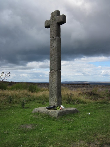
Young Ralph Cross

Geotag Icon Show on map

‘Young Ralph’ is much better known than his older brother, being on the logo of the North York Moors National Park.
Young Ralphs Cross
A cross at this location may date back as far as the 11th century, but the current cross is thought to be from the 18th century.
Young Ralphs Cross
The cross is currently in three pieces after being damaged in the1960s (see photo) and 1980s. It actually seems to have been extended compared to this old postcard, and the “R” seems to be no longer there.

ralphs-cross

The common tale told is that of a farmer called Ralph erected the cross after finding the body of a traveller here, the hollow carved in the top of the cross being left to hold coins for anyone in need of help. My grandfather would always stop here and lift me up to put coins in the top.