The Brent Alpha oil platform spent it’s working life about 100 miles NE of the Shetlands.

On the 24th June 2020 it entered the River Tees.

Travelling towards the Abel UK yard to be dismantled.

The Brent Alpha oil platform spent it’s working life about 100 miles NE of the Shetlands.
On the 24th June 2020 it entered the River Tees.
Travelling towards the Abel UK yard to be dismantled.
 Show on map
 This anchors stands outside the British Sub Aqua Club Hut at South Gare

Presumably it was recovered locally by the club, but i’ve been unable to find out exactly where from. Suggestion welcome as always
Show on map These extensive concrete remains lie just North of the current SSI Blast Furnace.
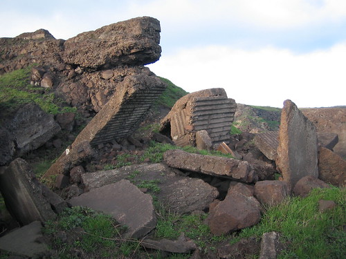


A post war map shows this structure between the Warrenby Slag Works and the Slag and Tarmacadam Works.

To me the layout of rails and concrete blocks suggest a row of storage hoppers which rail waggon could be driven underneath for loading, although i’m yet to find an old picture of what was actually here.
Show on map South Gare is entirely man made, it was constructed between 1866 – 1888, its 2.5 miles long and contains an estimated 5 million tons of slag from the local blast furnaces, which shows the vast size of the industry in that period.
 Â
 

This particular area contains some intact balls that havent been attacked by the sea or covered by sand and vegetation.
Show on map This cast iron sign must be exceptionally durable, its in a very exposed place but still seems to have much of its original paint despite the fact the Dorman Long became part of British Steel in 1967.

Show on map The two mounds carried 4.7″ Hotchkiss QF guns during WW1.


The mound closest to the river was re-used during WW2 when it held a BL 6″ Mk7.
An extensive battery covered the whole site, with much underground, but very little remains visible on the surface now.
Show on map These plinths would each hold a Bofors 40mm anti-aircraft gun, there are a total of four at the location 14ft apart.


Show on map The second mount for a 29mm Spigot Mortar that I located today.
I had previously misidentified something on the other side of the road as this several years ago.
 Â
 
Show on map 

Some people say this is a First World War jetty, it may well have been reused / rebuilt then but the 1894 OS maps already shows a tramway running from the powder wharf in the direction of the gare, joining up with the tramway on which sail bogies were also known to run. This would tie in nicely with 1880’s submarine mine loading complex on the gare which presumably needed a supply of explosives.
 Â Â Â
   
The small inlet immediately to the south east is known as Powder Hole.
Show on map The 265m long French aircraft carrier Clemenceau arrived on the Tees on Sunday 8th Feburary 2009, drawing a very large crowd at South Gare.
 Â
Â
It was towed from Brest by the tug Anglian Earl which moved it into position to be dismantled by Able UK on the North bank if the Tees.
 Â
 

