Bombardment of the Hartlepools

Geotag Icon Show on map

On my previous visit to the site in mid-2014 this monument did not exist, it appeared a few months later.

Bombardment of the Hartlepools

It commemorates the death of 114 civilians, 9 soldiers and 7 sailors killed in the Bombardment of the Hartlepools on 16th December 1914.

Bombardment of the Hartlepools

It was erected to mark the 100th Anniversary and unveiled on 16th December 2014 by the Lord-Lieutenant of County Durham Sue Snowdon.

Bombardment of the Hartlepools
Engraving on rear of monument

The engraving is tricky to photograph, but it a reproduction of the painting The Bombardment of the Hartlepools by James Clark, painted in 1915.

The Bombardment of the Hartlepools by James Clark, painted in 1915

A huge amount of information about the events of that day is on display in the nearby Heugh Battery.

Bombardment of the Hartlepools Fragment
Shrapnel from December 16th 1914

Royal Army Ordnance Corp – Brockley Hall Saltburn

Geotag Icon Show on map

This small painted sign can be found on a gatepost outside Brockley Hall. The property itself dates back to 1875 and became a Christian Endeavour Home in 1937.

I have no detais, but the sign would suggest it may have played a role in WW2 when the RAOC was responsible for the supply of ammunition, clothing and general stores. The “CSS” may stand for Combat Service Support.

No.1 C.S.S. / R.A.O.C Brockley Hall Saltburn

Darlington Station Bell

Geotag Icon Show on map

The Darlington Station Bell originally hung in the Clock Tower over the Victoria Road entrance to the station.

Darlington Station Clock Tower Bell

It was cast in 1886 by John Warner and Sons of London, who are best known for the clock chimes at the Houses of Parliament.

Darlington Station Clock Tower Bell

The bell had fallen out of use and was moved inside the station in 1983

Darlington Station Clock Tower Bell

Over Silton School 1844

Geotag Icon Show on map

This tiny village school in Over Silton carries an inscription that dates it 1844

Over Silton School 1844

The school house was built in 1844 by Sir George Wombwell, 3rd Baronet. After his death in 1855, his son Sir George Orby Wombwell, 4th Baronet (a survivor of the Charge of the Light Brigade) sold the Over Silton Estate.

Thompsons of Osmotherley Established 1786

Geotag Icon Show on map

Thompson’s in Osmotherley, began trading in 1786 and passed through six generation of the family.

Thompson Osmotherley 1786

Grace Thompson ran the shop alone and was still delivering newspapers aged 75 , she retired in 2004 and passed away in 2014.

A strict condition of the sale means any new owner has to run the building with all its original fittings as a shop, but unfortunately it still appears to be stood empty in 2022.

Charltons Methodist Chapel ?

This stone from a Methodist Chapel is in a modern bungalow opposite the community centre at Charltons. However old maps don’t show any previous buildings on this site.

It is also unclear whether Alderman J.T. Fletcher is associated with the 1873 date or the 18/2/61 (which must be 1961 if it was re-laid then?)

Charltons Methodist Church

This news report from 1874 hints work may have still being ongoing

Could it actually have been the chapel and school midway between Charltons and Margrove Park as suggested by 1890s Primitive Methodists circuits ?

Osmotherley Pinfold

Geotag Icon Show on map

Pinfolds were designed to hold stray animals until their owners paid a fine for their release.

Osmotherley Pinfold

They would have been a feature of all medieval villages, although this one dates from the 18th century.

Osmotherley Pinfold

Restoration work was done in 2011

Borrowby Cross

Geotag Icon Show on map

The cross in the centre of Borrowby is of medieval origin.

Borrowby Cross

The village is built at the junction of four roads and was once split between two wapentakes, Allerton and Birdforth. The portions which belonged to Birdforth were known as the Gueldable.

The English Heritage listing describes it very briefly as Ashlar. 3-step podium; plinth; short shaft; blocking course with rounded stone cross above.

Borrowby Cross

Boundary Stone – Hutton Mulgrave

Geotag Icon Show on map

A Perambulation is the periodic marking of estate boundaries by the Lord of the Manor, also known as “Beating the bounds”

Bounds

The stone carries many of the same dates as the nearby Swarthe Howe Cross.
1752
1774
1799
1885

Bounds

Hawsker Cross

Geotag Icon Show on map

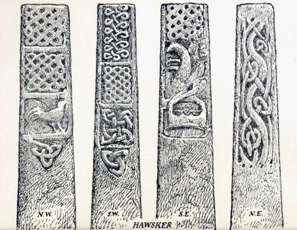
Hawsker Cross is thought to date from the 10th century, when a church or chapel may have stood on this site, it is missing the original cross-head.

Hawsker

My snapshot doesn’t do the carvings justice, but they have further worn since these drawing were made about a century ago.

Hawsker YAJ21WG Collingwood
Anglian & Anglo-Danish Sculpture in the East Riding with addenda to the North Riding. W.G. Collingwood. Yorkshire Archaeological Journal Vol. 21 1911. Yorkshire Archaeological Society. Leeds

The patterns are said to show strong Scandinavian influences, which would have arrived with the Danes/Vikings in Whitby after 867.