Blakey Ridge Water Trough

Geotag Icon Show on map

The trough which is fed by a nearby spring has featured on all OS maps since the first edition in the 1850s, although it now seems to have been dropped from the most modern mapping.
Trough

Trough

It looks to have been relatively recently cleared of vegetation and repaired, but I can find no information on it.

Rudland Rook (missing in action)

Geotag Icon Show on map

Rudland Rook (or maybe Rudland Rock) on the beautifully named Rotten Hill is one of the few boundary stones named on the OS map. Having got to the location theres no stone to be seen just a cairn (unless the stone is buried under the cairn)

Rudland Rook

A web search for Rudland Rook/Rock turns up very little, so if anyone know anything about it or why its marked on maps I would love to know.

Young Ralph Cross

Geotag Icon Show on map

‘Young Ralph’ is much better known than his older brother, being on the logo of the North York Moors National Park.
Young Ralphs Cross
A cross at this location may date back as far as the 11th century, but the current cross is thought to be from the 18th century.
Young Ralphs Cross
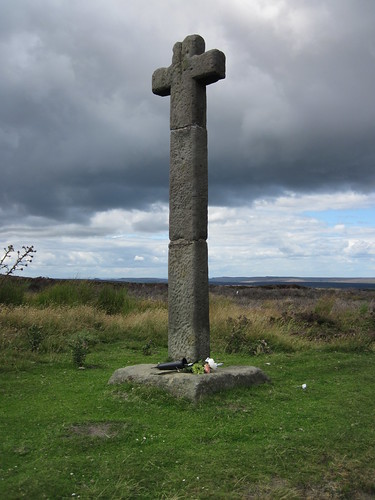
The cross is currently in three pieces after being damaged in the1960s (see photo) and 1980s. It actually seems to have been extended compared to this old postcard, and the “R” seems to be no longer there.

ralphs-cross

The common tale told is that of a farmer called Ralph erected the cross after finding the body of a traveller here, the hollow carved in the top of the cross being left to hold coins for anyone in need of help. My grandfather would always stop here and lift me up to put coins in the top.


Gallow How Boundary Stone

Geotag Icon Show on map

As well as the words “Gallow How” this stone carried the letter “D” for Danby and “W” for Westerdale as it marks the parish boundary.
Gallow How Stone
It also carries the date 1835
Gallow How Stone
Whether or not a set of gallows ever stood here is unknown to me, ‘Gallow Howe’ suggests a much older bronze age burial mound.

Midge Lamp, New Marske Roundabout

Geotag Icon Show on map

This sculpture of an ironstone miners ‘Midge’ lamp by Graham Anderton is still a work in progress and has not yet been officially unveiled.
At the end of July 2013 it looked like this on a metal base.
Midge Lamp, New Marske
In fact when it first arrived in April 2013 there was a miner with tools sat on the edge as can be seen in this photo taken by Nekoglyph (presumably he may return)
Miner's lamp sculpture
When I passed by in early August its now sitting on top of a mine spoil heap.
MIners Lamp (plus spoil heap)

Marske Bypass Plaque

Geotag Icon Show on map

I have read that the railing are about to be replaced tonight, so there’s a fair chance the battered old plaque may end up on a scrap van too.
Marske By-Pass

Cleveland County Council
Marske-By-Pass
Opened on Friday 9 December 1977
The Rt Hon W T Rodgers MP Secretary of State for Transport
Chairman of Highways and Transportation Committee
Councillor Jim Tatchell BSc (Eng) F I E E
County Surveyor and Engineer
Edwin Shaw BSc.DIP.TP C.ENG. M.I.C.E.M.R.P.T.I
Contractor A. Monk & Co Ltd

Crypt at St Mary’s, Lastingham

Geotag Icon Show on map

The crypt at St Marys is believed to date from 1078 – 1086 and was built over the place where St Cedd was buried.
St Marys Lastingham, Crypt
Inside are a number of fragments of crosses and earlier church buildings.
St Marys Lastingham, Crypt
The pillar with snakes is thought to date from the 10th century,  with a much simpler sword carved onto the stone in the background.
St Marys Lastingham, Crypt
These two fragments in the foreground may be from an 8th century shrine.

Cannon Lake, Albert Park, Middlesbrough

Geotag Icon Show on map

Between 1866 and 1947 Middlesbrough’s Trophy Cannon stood by the Upper Lake in Albert Park, which became known as ‘Cannon Lake’.
Cannon Lake, Albert Park, Middlesbrough
Clare Hindmarsh kindly let me use these photographs of the cannon taken some time between 1929 and 1933.
Cannon Lake, Albert Park, Middlesbrough

The cannon finally got back into the park in 2001, but the lake is long gone.upper

Boulby Potash Shaft Headgear Demolition

Geotag Icon Show on map

Last weekend the old shaft headgear was moved away at 50mm per minute before being replaced by a new ready assembled tower.
On Monday 5th of August the old headgear was demolished in a controlled explosion, fortunately one of my friends was there to capture it for the website.

St Cedds Well, Lastingham

Geotag Icon Show on map

This attractive well named after St Cedd of Lastingham was constructed in the 19th century, apparently reusing 12th century stone from Rosedale Abbey. Sadly the lions mouth is currently dry.

Cedds Well, Lastingham
The wooden plaque reads.
CEDD
ABBIE LASTINGAE FUNDATOR
AD 654
OBIIT AD 664 ET SEPULTUS EST
IN ECCLASIA A DEXTRA ALTARIS
Cedds Well, Lastingham
My Latin isn’t up to scratch, but Google Translate suggests he established the monastery at Lastingham in AD 654 (other websites suggest AD 658) and was buried in the church to the right of the altar in AD 664.