Greenabella QF Decoy Site, Greatham Creek

Geotag Icon Show on map

After a little more research and some input from readers i’m now confident these are the remains of a QF decoy site called Greenabella. These sites lit controlled fires during air raids to appear as targets struck by bombs. This location was a civil decoy for Middlesbrough.

A reference in ‘Fields of Deception’ by Colin Dobinson idenifies a generator house and site shelter at this location.
Mystery Structures, Greatham Creek
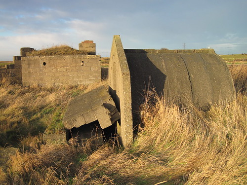
Both have an offset entrance or a blast wall for protection
Mystery Structures, Greatham Creek

I think the larger structure with the holes for pipes and a chimney is likely to be the generator building, with the smaller structure the shelter.
Mystery Structures, Greatham Creek
Other decoy sites in the area also have unusual structures.

Stokesley Mill Wheel

Geotag Icon Show on map

This water wheel dates from around 1850 and was part of Fidlers Mill, which was only demolished as recently as 1983.
Stokesley Mill Wheel
The actual location of mill was under the co-op car park, and its thought a mill existed on that site since the times of the Domesday book.

St Johns Church, Haverton Hill

Geotag Icon Show on map

All that remains of the church from 1865 is the lych gate and graveyard.
St Johns, Haverton Hill / Port Clarence.
The church was demolished in the late 1960s along with most of Haverton Hill due to heavy pollution.
I have only been able to find one tiny composite photo of what the church actually looked like.


Hutton Rudby Water Pump

Geotag Icon Show on map

This pump stands in the middle of the village green, it doesnt work as its also a flower pot.
Hutton Rudby
The plaque on the rear records it was donated by Dr and Mrs G Rider in July 2000 to commemorate the millenium.
Hutton Rudby

18th Century Houses, Hutton Rudby

Geotag Icon Show on map

A number of the houses around the village green in Hutton Rudby have date stones from the 1700s
Hutton Rudby
A booklet about the village by Alice Barrigan suggests the house dated 1745 was once a pub, possibly called the William IV, it still has a horse mounting step outside.
Hutton Rudby
This stone names David & Everell Simpson – AD 1754
Hutton Rudby
Nearby Mary Tunssall – AD 1755
Hutton Rudby

I alwasy find it fascinating that most small villages usually contain buildings that pre-date events such as the creation of the USA.

The Flaming Stump and the Portrack Cut

Geotag Icon Show on map

The Flaming Stump was an inn that stood on Portrack Lane, by the banks of the Tees. It was rumoured to be heavily involved in smuggling and featured the eloborate ‘Angel Room’ sculpted by a craftsman called Palini

The course of the Tees was shortened and straightened by the Tees Navigation Company and the Portrack Cut was completed in 1831, although the old course of the river is still very apparent on this 1899 map before the area was developed. This change lead to the inn closing and becoming Portrack Grange Farm also shown on the map below.

The buildings were still in existance as late at 1959 before being demolished, fortunately a photograph exists of the Angel Room in 1950

Pillbox near Cowpen Bewley

Geotag Icon Show on map

This type 23 pillbox now stands at the edge of a trading estate between Cowpen Bewley and Haverton Hill.

Cowpen Bewley, Pillbox
Its positioning is a little mysterious as its well away from the road and old maps show nothing in the area but empty fields. Although there was much industry in the general area.
Cowpen Bewley, Pillbox

John Walkers Grave, Norton

Geotag Icon Show on map

The inventor of the friction match in around 1827, died 1 May 1859 and was buried here.
John Walkers Grave, Norton
This is actually a replacement headstone from July 1972 and it says the original is in the Preston Park museum
John Walkers Grave, Norton
However the heavily weathered stone next to it also mentions John Walker which seems a bit too co-incidental, although its too worn to make out any dates.
John Walkers Grave, Norton

175 years since death of Redcar Lifeboatman

Geotag Icon Show on map

William Guy is the only Redcar Lifeboatman ever to lose his life on a rescue callout.
William Guy, St Peter Redcar
He died on Christmas Day 1836 after being lost overboard from the Zetland lifeboat while trying to save the crew of the Danish ship Caroline.

The Caroline’s crew were also lost and Guys body was not found until 17 days later, near Staithes. (although All of Her Past Glories by David Phillipson says 6 weeks)

A plaque was unveiled in May 2011 in St Peter Church and a new grave marker laid in the cemetery.
William Guy, St Peter Redcar