St Mary Magdalene Church, Hart was founded in 675 AD
The current tower dates to the 13th century and the nave the 12th century. A carving on the wall is generally said to depict St. George and the Dragon.
However it could relate to the Clifford Family who owned the Manor House estate. Rather than a dragon it may show a wyvern which features on the Clifford family crest.
This stone from a Methodist Chapel is in a modern bungalow opposite the community centre at Charltons. However old maps don’t show any previous buildings on this site.
It is also unclear whether Alderman J.T. Fletcher is associated with the 1873 date or the 18/2/61 (which must be 1961 if it was re-laid then?)
This news report from 1874 hints work may have still being ongoing
Could it actually have been the chapel and school midway between Charltons and Margrove Park as suggested by 1890s Primitive Methodists circuits ?
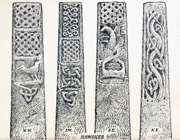
Hawsker Cross is thought to date from the 10th century, when a church or chapel may have stood on this site, it is missing the original cross-head.
My snapshot doesn’t do the carvings justice, but they have further worn since these drawing were made about a century ago.
Anglian & Anglo-Danish Sculpture in the East Riding with addenda to the North Riding. W.G. Collingwood. Yorkshire Archaeological Journal Vol. 21 1911. Yorkshire Archaeological Society. Leeds
The patterns are said to show strong Scandinavian influences, which would have arrived with the Danes/Vikings in Whitby after 867.
Leake church now stands alone by the A19, it once served the now deserted Medieval village of Leake; it now serves the two villages of Borrowby and Knayton.
Mass dials are a type of medieval sundial found on churches, they were used to show the time of services held during the day before the advent of clocks and watches.
They are also known as Scratch dials because many are scratched into the stone. The hole in the centre held a rod that cast a shadow, known as a gnomon.
On the corner of Walkers Row and Union Street, nestled next to a tumble drier vent is a fragment of Gisborough Priory. It actually looks like the base of a small column, perhaps from a window ?
Many chunks of the priory were reused across the town after the Dissolution of the Monasteries in 1540, although how this one ended up in a relatively modern building is a mystery.
The foundation stone for St Peters in Redcar was laid on Monday 30th June 1823, with the events of the day being reported in detail in the Durham County Advertiser.
Durham County Advertiser 1823
I wonder if the ‘time-capsule’ of documents and coins is still inside the building, or whether it was disturbed by later changes, a rough translation of the Latin inscription is :-
The first stone is placed Feast of St Peter 1823
King George IV Ruling Edward Venables Vernon, Archbishop of York Baron Lawrence Dundas, Lord of Manor Joseph Harrison, Vicar
Fund raising and completion was a major a problem and the £1100 costs had become £2700 by it was finally finished in 1829.
This etching is said to date from 1826, so the church was incomplete at this point and it may have still been an impression of what it should look like.
1826 etching
Things to notice about this compared to St Peters today are that no clock is visible (this was added in 1835) and there are only 4 sets of windows at the side not 5 (the church was extended in 1848) and no Lady Chapel at the rear (built much later in 1926)
The current travel restrictions mean i’ve been able to take a closer a look at things very close to home in a lot more detail.
The East Cleveland Baptist Church has a large number of inscribed stones on the Stanley Grove side that I had never noticed before. Mr A R Doggart J.P is named as the President in 1928, so I suspect that’s the date the building was erected.
Members of the Church Mrs M J Agar, Mr A R Doggart J.P President 1928
Arthur Robert Doggart was President of the Baptist Union at this time and remained so until his death in 1932. Doggarts owned a chain of department stores based in Bishop Auckland.
Arthur Robert DoggartDoggarts 1917 advertDr Wynne Williams, Alderman J MorlandAlderman J Morland, died in 1934Mrs McGregor, Mrs Hickson, Mrs S Foster, Mr T Potter, Mr J. W. SlackMiss Anderson, Miss Murray, Children of the Sunday School , (Angus Stewart ?)
Fortunately I have found a news report about the ceremony in which these stones were laid on Saturday 15 December 1928. The building cost £3170.
Yorkshire Post and Leeds Intelligencer – Monday 17 December 1928
West End Methodist Chapel was built in 1877 for the Wesleyan branch of the Methodists. It was built for a congregation of about 500 people at that time.
The final service took place on 14th October 2012 and the building is now home to Puma Cheer and Dance.
Primitive Methodists split from the Wesleyan Methodists in 1807 and continued until the Methodist Union in 1932. They became known as the “‘Ranters” due to their evangelical preaching.
Hitherto Hath The Lord Helped Us
They had a strong following among the poor and working class, which perhaps explains the involvement of local ironstone mine owners Pease and Bell Brothers.
There’s an account of the opening of Skelton Primitive Methodist chapel by H Pratt in the Primitive Methodist magazine of April 1866
The cost was around £259, Donors included Jos. Pease, Mr Bell, Earl of Zetland, J Wharton, J Pease MP, G Pease, Captain Challoner, FA Millbank MP and Jos Fawcett.
The Primitive Methodist Chapel was built on Chapel Street in 1860 at a cost of £425, the plaque now worn flat and painted blue presumably once carried the name and date.
Guisborough Cons Club 2019
In 1907 they relocated to much larger premises on Westgate at a cost of £4000, which is still a Methodist church. The site is now the Guisborough Cons Club .


 Show on map