Yarm / Egglescliffe Pillbox

Geotag Icon Show on map

The pillbox is located on some wasteland overlooking the river crossing.
Yarm, Pillbox
Yarm, Pillbox
Its a little grotty inside as I imagine its been a teenage drinking den for years.
Yarm, Pillbox

Theres an interesting comment on the Picture Stockton website by Martin Jones who states :-
My Grandfather Oswald Bell used to help man the pillbox as part of the 19th Stockton Battalion Home Guard, they kept their ammo in one of the Vinegar Brewery room

Ingleby Arncliffe Water Tower

Geotag Icon Show on map

This decorative tower was designed by Walter Brierley Ingleby Arncliffe Water Tower
The inscription records the fact that Sir Hugh Bell built the tower in 1915 to supply water to Arncliffe and Rounton. The Bell family being heavily involved in iron and steel making in Teesside.
Ingleby Arncliffe Water Tower

Dr Tony Power tells me George Walker Milburn carved the Coat of Arms over the entrance door to the Tower in 1915, for Sir Hugh Bell, at a cost of £17 0. 0.

In front the doorway are some colored stones which spell out “H&FB 1915” which are the initials of Sir Hugh Bell and his wife FlorenceIngleby Arncliffe Water Tower

Foxton Bridge Pillbox

Geotag Icon Show on map

Another link in the Northern Command: 59 Div. Reserve Stop Line, the same as the example posted yesterday.
Foxton Bridge Pillbox
Another Type-23 pillbox with an entrance in the top, i’m no military tactician but the view it commands over the river crossing speaks for itself.
Foxton Bridge Pillbox
Inside is partially filled with soil that has fallen in from above, but its otherwise in good condition.
Foxton Bridge Pillbox

Pillbox, Ingleby Barwick

Geotag Icon Show on map

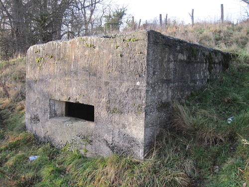
Despite being only a few hundred meters from the edge of a huge housing estate, this pillbox that formed part of the Northern Command: 59 Div. Reserve Stop Line is in excellent vandal-free condition.
Ingleby Barwick Pillbox
The pillbox is of a Type-23 design with an entrance in the roof and still has its pillar for mounting a light anti-aircraft defence: a Bren or Lewis gun.
Ingleby Barwick Pillbox
The gun shelf is still intact inside
Ingleby Barwick Pillbox

The Defence of Britain website gives the following detailed information :-

“From Malton N 59 Div. established a divisional reserve line. The position ran from Malton up to Hovingham, Oswaldkirk and Helmsley, where the planned line of defences was broken. The line resumed at Carlton in Cleveland, before continuing N to Hutton Rudby, then along the River Leven to its junction with the Tees. The Tees was followed as far Stockton, from where the line followed a railway route as far as the N divisional boundary.”

1932 County Borough Marker, Marton, Middlesbrough

Geotag Icon Show on map

The County Borough of Middlesbrough was extended in 1932 and the Middlesbrough Rural District of which Marton was part abolished.
1932 Middlesbrough County Borough Marker
Many thanks to the people who pointed this marker out to me after I mentioned the one on the other side Stewart Park

Slip Inn Bank

Geotag Icon Show on map

Slip Inn Bank was an accident black-spot on Ladgate Lane that was removed when the road was redirected, an 18th century bridge over Marton West Beck still stands on the now dead-end road.
Slip Inn Bank, Bridge

The vanished ‘Slip Inn’ pub (demolished 1963) is shown in this Evening Gazette article.
I’ve also found a couple of references to it being unlicensed and an Irishman was kicked to death in a brawl on the bridge.

Fairy Dell, West of the Lake

Geotag Icon Show on map

More Steve Iredale carvings are to be found on the west side of the lake.
Carvings, Fairy Dell, Marton
Some acorns near the entrance to the park
Lizard, Fairy Dell, Marton
A newt from a tree stump
Heron, Fairy Dell, Marton
A heron dedicated to Terry Ward

The Friends of Fairy Dell are still an active group if you want to lend your support

Fairy Dell, Gunnergate Hall, East of the Lake.

Geotag Icon Show on map

Near the upper lake is a plaque showing Gunnergate Hall, the plaque says originally built by Charles Leatham in 1857 although other sources say it dates from the 1820s
It was later owned by Ironmaster John Vaughan and after his death by Middlesbrough shipbuilder and mayor Sir Raylton Dixon. It was unoccupied after 1901 although brought back into use as an army base during both World Wars, then unfortuantely demolished in 1946
Gunnergate Hall, Fairy Dell, Marton
The outline a boat house is visible next to the lake with an ornamental waterfall to the lower lake.
Boat House, Fairy Dell, Marton
Waterfall, Fairy Dell, Marton
Next to the lake is a bird hide constructed in 2007
Bird Hide, Fairy Dell, Marton
Along with some more Steve Iredale carvings from felled trees
Carvings, Fairy Dell, Marton

Fairy Dell, South of the Lake

Geotag Icon Show on map

Fairy Dell is the garden of the lost Gunnergate Hall which was the home of ironmaster John Vaughan. The park contains a number of sculptures as well as few reminders of the hall.
Dragon, Fairy Dell, Marton
The Dragon was carved by Steve Iredale in 2006
Snake Bridge, Fairy Dell, Marton
The Snake Bridge around the same time

Wilton Clay Drift

Geotag Icon Show on map

Bolckow and Vaughan operated a shallow mine between 1914 and 1920 in a small pocket of isolated ironstone.
Wilton Clay Drift
The standing building is an electrical substation, while a totally collapsed and flooded drift entrance can be found next to it.
Wilton Clay Drift